HoliTracer: Holistic Vectorization of Geographic Objects from Large-Size Remote Sensing Imagery
Holistic Vectorization Tracing in 1080P: Conventional patch-based vectorization cuts large geographic objects into fragmented tiles. HoliTracer performs holistic vectorization across full-scene satellite imagery: starting from an initial contour, the active Polygon Sequence Tracer (PST) window walks along the sequence, autoregressively snapping points and lighting up golden corner vertices to synthesize a seamless, topologically closed vector polygon.
Abstract
Method Overview
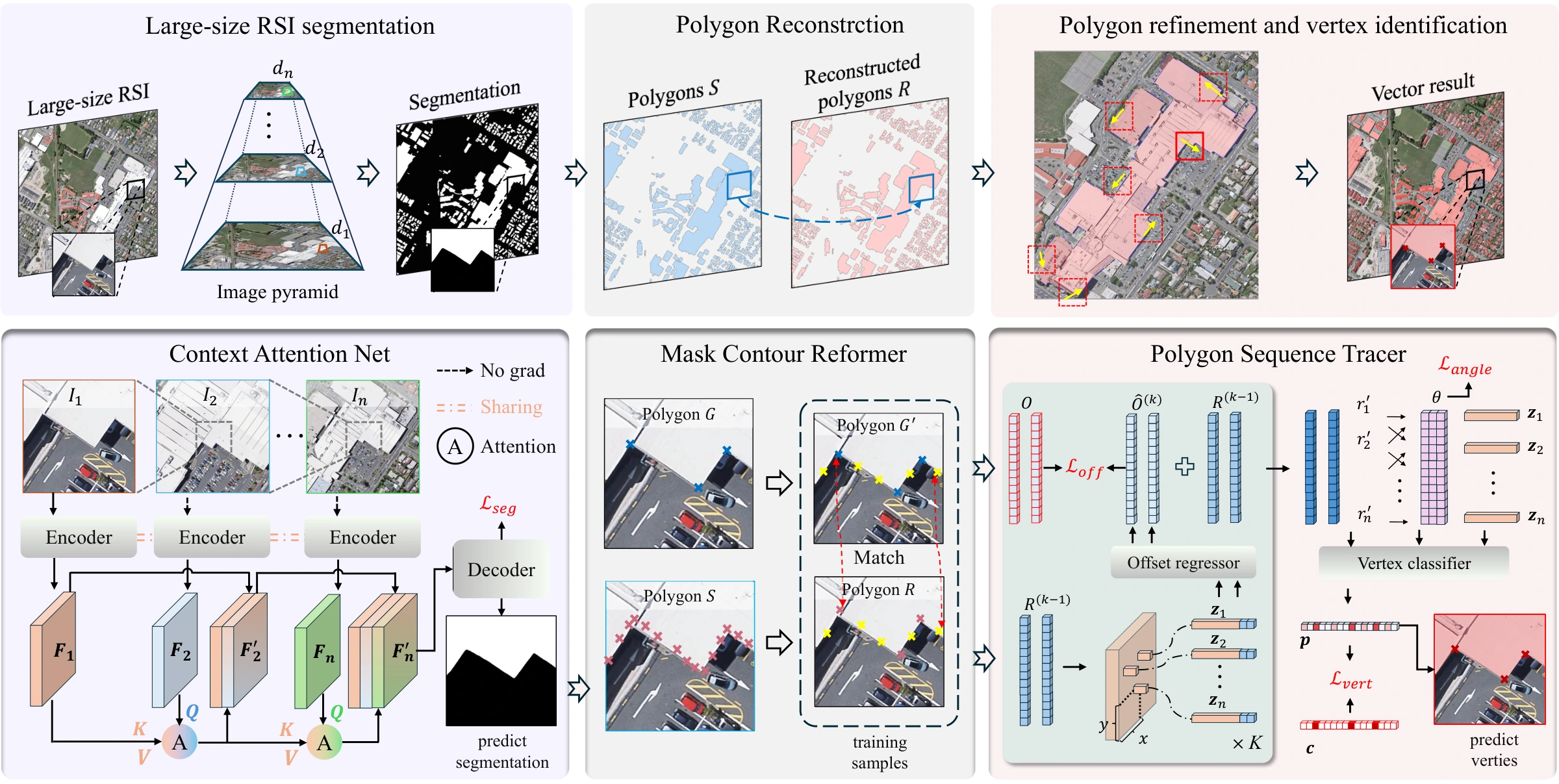
The Overall Framework of HoliTracer: HoliTracer is composed of three interconnected modules: (1) Context Attention Net (CAN) for multiscale semantic segmentation of ultra-large satellite imagery; (2) Mask Contour Reformer (MCR) for robust initial polygon boundary reconstruction; and (3) Polygon Sequence Tracer (PST) for autoregressive vertex identification, geometric corner refinement, and topological contour closure. This holistic architecture eliminates tile boundary cutting and produces seamless GIS-grade vector polygons.
Quantitative Results
| Method | PoLiS (↓) | CIoU (%) | AP | APs | APm | APl | IoU (%) | F1 (%) |
|---|---|---|---|---|---|---|---|---|
| TS-MTA | 6.94 | 14.29 | 36.33 | 14.34 | 65.49 | 41.30 | 85.30 | 92.02 |
| LCF-ALE | 7.51 | 19.09 | 41.78 | 20.05 | 64.44 | 38.98 | 85.67 | 92.22 |
| DeepSnake | 4.43 | 53.54 | 38.83 | 22.31 | 53.17 | 15.47 | 76.05 | 86.01 |
| E2EC | 9.10 | 47.66 | 29.85 | 17.03 | 41.32 | 8.87 | 65.44 | 78.49 |
| FFL | 9.34 | 35.51 | 31.39 | 17.03 | 48.29 | 26.92 | 71.48 | 83.25 |
| UniVec | 8.36 | 62.26 | 30.13 | 16.86 | 42.18 | 27.90 | 78.66 | 87.96 |
| HiSup | 5.49 | 42.23 | 56.77 | 36.08 | 69.44 | 37.82 | 85.79 | 92.21 |
| HoliTracer (Ours) | 3.63 | 82.30 | 61.07 | 40.37 | 80.30 | 60.00 | 91.60 | 95.41 |
Qualitative Results

Qualitative Vectorization Comparison: Holistic vectorization results across diverse geographic object classes—dense residential buildings, intricate hydrological networks, and multi-lane arterial road systems. HoliTracer maintains sharp corners, regular geometry, and closed topology across full-scene imagery without tile seams.
Citation
@inproceedings{wang2025holitracer,
  title={HoliTracer: Holistic Vectorization of Geographic Objects from Large-Size Remote Sensing Imagery},
  author={Wang, Yu and Dang, Bo and Li, Wanchun and Chen, Wei and Li, Yansheng},
  booktitle={Proceedings of the IEEE/CVF International Conference on Computer Vision (ICCV)},
  year={2025}
}